Showing posts with label celestial sphere. Show all posts

Monday, August 12, 2019

Spherical Astronomy Revisited (1)

Spherical astronomy entails the mastery of the basic relations for spherical trigonometry. This is merely an extension of plane trig, but to the sort of angles (many > 90 degrees) one finds in astronomical applications, since distances, angles are of spherical measure (derived from spherical triangles.)        A simple illustration of spherical geometry is shown in Fig. 1. In the diagram, the angle Θ denotes the longitude measured from some defined meridian on the sphere, while the angle φ denotes a zenith distance, or the measured angle from an object to the zenith. 


Fig. 2 shows a spherical right triangle from which a host of different angle relationships can be obtained, which can then be used to find astronomical measurements, etc. 


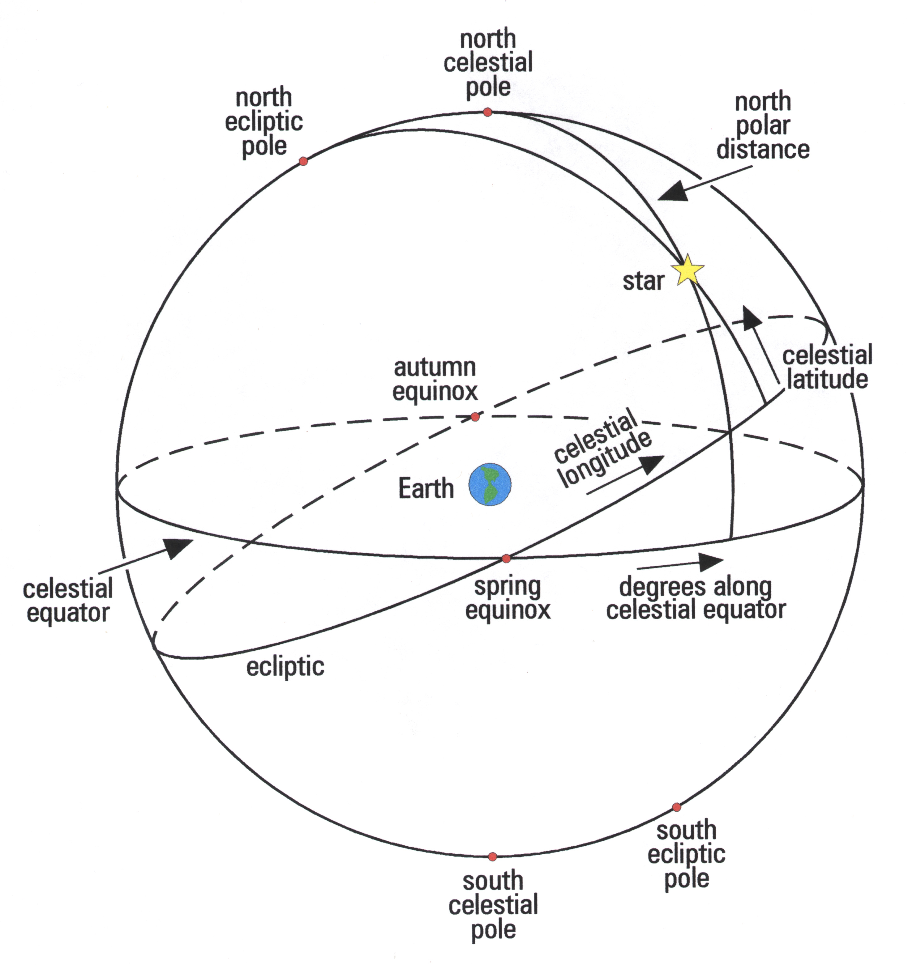
Fig.3 shows a diagram of the celestial sphere, such as used in many practical astronomy applications, and some of the key angles with reference to a particular object (star) referenced within a given coordinate system:


In some applications, the coordinate system may not need to be changed, but in others it must - for example, when going from the coordinate system applied to sky objects (Right Ascension, Declination) to the observer's own coordinates (altitude, azimuth). In this way, coordinate transformations will also enter and are straightforward to perform, for example via use of matrices.

We consider first a simple angle relation in Fig. 1, say to find the altitude, a. Then if we have the basic geometrical relationship: a + φ = 90 degrees, then a = (90 - φ).

    Let's now examine Fig. 2 and see what spherical trig relationships we can infer.

 Two of the key ones embody the law of sines and law of cosines for spherical triangles, which are the analogs of the law of sines and cosines in plane trig.

We have for the law of sines:

Sin A/ sin a = sin B/ sin b = sin C/ sin c

where A, B, C denote ANGLES and a,b,c denote measured arcs. (Note: we could also have written these by flipping the numerators and denominators).

We have for the law of cosines:

cos a = cos b cos c + sin b sin c cos A 

Where a, b, c have the same meanings, and of course, we could write the same relationship out for any included angle.

   Now, we use Fig. 3, for a celestial sphere application, in which we use the spherical trig relations to obtain an astronomical measurement.

Using the angles shown in Fig. 3 each of the angles for the law of cosines (given above) can be found. They are as follows:

cos a = cos (90o -
d)

where
d = declination

cos b = cos (90 o - Lat)

where 'Lat' denotes the latitude. (Recall from Fig. 1 if φ is polar distance (which can also be zenith distance) then φ = (90 - Lat))

cos c = cos z

where z here is the zenith distance.

sin b = sin (90 deg - Lat)

sin c = sin z

and finally,

cos A = cos A

Where A is the azimuth.


Example Problem:

Let's say we want to find the declination of the star if the observer's latitude is 45 o N, the azimuth of the star is measured to be 60 o, and its zenith distance z = 30 o. Then one would solve for cos a:

cos a = cos (90 o -
d)=

cos (90 o - Lat) cos z + sin (90 o - Lat) sin z cos (A)

cos (90 o -
d) =  cos (90 o - 45 o) cos 30 o

+ sin (90 o - 45 o) sin 30 o cos 60 o

And:

cos (90 o -
d) = cos (45 o) cos 30 o

+ sin (45 o) sin 30 o cos 60 o

We know, or can use tables or calculator to find:

cos 45 o =
Ö2 / 2

cos 30 o =
Ö3/ 2

sin 45 o =
Ö2/ 2

sin 30 o = ½

cos 60 o = ½

Then: 

cos (90 - d)= {(Ö2/ 2 )( Ö3/ 2)} + {Ö2/ 2} Ö (½) }

cos (90 -
d)= Ö6/ 4 + Ö2/ 8 = {2Ö6 + Ö2}/ 8

cos (90 -
d) = 0.789

arc cos (90 -
d)= 37.o

Then:

d = 90 o - 37. o 9  = 52. o 1

Or, in more technical terms:

d (star) = + 52.1 degrees

A more detailed image of the celestial sphere appears below with key aspects not found in the simpler version (Fig. 3):
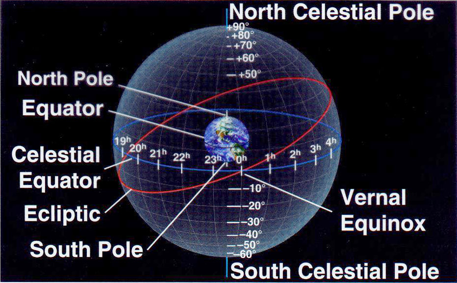
Image result

In this detailed version we see the Earth's north pole is projected to the North Celestial Pole, the equator is projected to the celestial equator, and all latitude lines are projected to become declination lines, while longitude lines become Right Ascension lines. Thus, just as every geographical location on Earth has a latitude and longitude so also every sky location has a declination and Right Ascension.   The "vernal equinox" position, for example, is at 0 degrees Declination and 0 hours RA.  (The vernal equinox marks the  first day of spring.) 

The oblique red circle projected onto the celestial sphere defines the ecliptic or the projected (apparent) path of the Sun onto the celestial sphere through the year.  If we follow the red circle - the ecliptic - UP from the vernal equinox we come to the northernmost point at +23.5 degrees declination and 6h  RA. This coincides with the summer solstice - or when the Sun appears over that latitude on Earth. This marks the longest day of the year in the northern hemisphere

We are led then to consider how to compute star positions on this sphere (which had the designated coordinates of R.A. and declination) and also how to transform between coordinate systems, say between the horizon system and the celestial sphere  (equatorial) system.    

For example, the coordinate system depicted  in the color graphic above - the equatorial system - is based on the projections of the Earth's own equator and N. and S. poles onto the sky sphere.  The poles then become the North and South Celestial poles, and the equator becomes the celestial equator. If these poles are defined respectively at +90 degrees (NCP) and -90 degrees (SCP) and the celestial equator at 0 degrees, then a system of celestial latitude can be constructed.

 Once the vernal equinox position is fixed at 0 hours R.A. then the celestial longitude emerges and spans 24 hours across the same celestial sphere.  (Refer again to color graphic for direction of celestial longitude circles.) These can be used in conjunction with celestial latitude (declination)  to locate any celestial object. It is then possible to make computations translating one system's coordinates to those of others (horizon, ecliptic etc.) 

Example: φ = 51.5 degrees N, for London. Now, for the December (winter) Solstice the Sun is directly over the Tropic of Capricorn (φ  = 23.5 S) therefore we do know its declination is - 23.o5. We have then for the Sun's azimuth at sunrise in London on Dec. 21:

cos (A) = sin (-23.o 5)/ cos (51.o 5)

which gives approximately, 130 o.


  Where is this on our directional reference circle for azimuth? We know that 180 degrees is due South so that this must be: 

40 degrees SOUTH of due East. (90 o + 40 o = 130 o)

Now, on the longest day of the year (say June 21), the Sun is over the Tropic of Cancer at 23.5 N latitude, so the Sun's declination is + 23. o 5 . Then the azimuth for that date is:

cos (A) = sin (23. o 5)/ cos (51. o5)

And A = 50 o

This puts the Sun's rising position North of due E. or specifically 40 degrees North of due East.    


Problem:


The altitude of a star as it transits your meridian is found to be 45o along a vertical circle at azimuth 180o, the south point.  Find the declination of the star.

Friday, February 1, 2019

Selected Questions- Answers From All Experts Astronomy Forum (Spherical Astronomy)

Question: I am a recent (2014) Mathematics graduate and would like to learn more about spherical astronomy. What exactly is it?  How does it work, i.e. what sort of computations and what objectives? And what are the best texts to get to learn more?  - Mason Dix, Louisville, KY

Answer:   According to author W.M. Smart ('Textbook On Spherical Astronomy', Cambridge University Press, 1931):  Spherical Astronomy:

"is concerned essentially with the directions in which stars are viewed, and it is convenient to define these directions in terms of the positions on the surface of a sphere - the celestial sphere - in which straight lines joining the observer to the stars intersect the surface."

This is probably as complete a definition as one will find without going into much more details. But at the very least it's clear one requires a spherical geometry.  This isn't difficult to grasp when one realizes a spherical geometry essentially was obvious from antiquity to anyone who looked up at the stars, e.g.
No photo description available.

So what the observer would detect appeared to be on the inner surface of an immense sphere.  The earliest spherical analog then was based on the central observer looking outward as if to a dome. It then was later tweaked and refined and became know as the horizon system - marked by the cardinal directions of the compass (N, S, E,W) and measuring altitude and azimuth.

The next step was for ancient observers to recognize the need for an independent spherical system with which the star positions could be pinpointed. This then introduced the celestial sphere concept:Image result
Thus, the north pole is projected to the North Celestial Pole, the equator is projected to the celestial equator, and all latitude lines are projected to become declination lines, while longitude lines become Right Ascension lines. Thus, just as every geographical location on Earth has a latitude and longitude so also every sky location has a declination and Right Ascension.   The "vernal equinox" position, for example, is at 0 degrees Declination and 0 hours RA.  (The vernal equinox marks the  first day of spring.) 


The red circle projected onto the celestial sphere defines the ecliptic or the projected (apparent) path of the Sun onto the celestial sphere through the year.  If we follow the red circle - the ecliptic - UP from the vernal equinox we come to the northernmost point at +23.5 degrees declination and 6h  RA. This coincides with the summer solstice - or when the Sun appears over that latitude on Earth. This marks the longest day of the year in the northern hemisphere.

So inevitably the next logical step became how to compute star positions on this sphere (which had the designated coordinates of R.A. and declination) and also how to transform between coordinate systems, say between the horizon system and the celestial sphere system.  

 This is critical given each such coordinate system is defined by a different set of poles and equator. For example, the coordinate system depicted  in the color graphic above - the equatorial system - is based on the projections of the Earth's own equator and N. and S. poles onto the sky sphere.  The poles then become the North and South Celestial poles, and the equator becomes the celestial equator. If these poles are defined respectively at +90 degrees (NCP) and -90 degrees (SCP) and the celestial equator at 0 degrees, then a system of celestial latitude can be constructed.  

Once the vernal equinox position is fixed at 0 hours R.A. then the celestial longitude emerges and spans 24 hours across the same celestial sphere.  (Refer again to color graphic for direction of celestial longitude circles.) These can be used in conjunction with celestial latitude (declination)  to locate any celestial object. It is then possible to make computations translating one system's coordinates to those of others (horizon, ecliptic etc.) 

Consider this example which seeks to find the star’s declination.

The altitude of a star as it transits your meridian is found to be 45 deg along a vertical circle at azimuth 180 deg, the south point. Find the declination  
d of the star.

Since this was designed for students at latitude 13 degrees north, the key to the solution rests on the recognition that z, the zenith distance is negative. From the geometry of Fig. 3  one sees that:

90o = z + a or z = 90o - a = 90o – 45 o = 45 o

But since we require: z = φ (latitude) = 13 o

Then z must have a negative value, or: (-45 o), since:

d = z + φ = (-45 o) + 13 o = -32 o

    This makes sense, since by examining the right side of Fig. 2.,  the zenith distance z, plus altitude (a) must equal 90 degrees and we know CE (celestial equator) defines 0 degrees declination, then a star’s altitude of a = 45 o shows it to be SOUTH of CE. How much? Ans. 90 o - 45 o = 45 o.

 But,  this is still 32 o south of CE, and hence must be negative in value.

Another wide application of spherical astronomy is to find the azimuth of the Sun for particular dates, and locations.  In general: 

cos (A) = sin(
d)/ cos (φ)

 where A is the azimuth of the Sun, 
d denotes its declination, and φ is the observer’s latitude. (Note that d may be obtained from a table but can also be estimated from the equinox/solstice positions, i.e. +23 ½ o at solstices, 0 degrees at equinoxes.
Example: φ = 51.5 degrees N, for London. Now, for the December (winter) Solstice the Sun is directly over the Tropic of Capricorn (φ  = 23.5 S) therefore we do know its declination is - 23.o5. We have then for the Sun's azimuth at sunrise on Dec. 21:

cos (A) = sin (-23.o 5)/ cos (51.o 5)

which gives approximately, 130 o.


  Where is this on our directional reference circle for azimuth? We know that 180 degrees is due South so that this must be: 

40 degrees SOUTH of due East. (90 o + 40 o = 130 o)

Now, on the longest day of the year (say June 21), the Sun is over the Tropic of Cancer at 23.5 N latitude, so the Sun's declination is + 23. o 5 . Then the azimuth for that date is:

cos (A) = sin (23. o 5)/ cos (51. o5)

And A = 50 o

     This puts the Sun's rising position North of due E. or specifically 40 degrees North of due East.    


Now, we  can again use Fig. 3, for a celestial sphere application, in which we use the spherical trig relations to obtain an astronomical measurement, say for declination of an object.

    Using the angles shown in Fig. 3 each of the angles for the law of cosines (given above) can be found. They are as follows:

cos a = cos (90o -
d)

where
d = declination

cos b = cos (90 o - Lat) 


Where 'Lat' denotes the latitude of the observer.  Further:

cos c = cos z

where z here is the zenith distance.

sin b = sin (90 deg - Lat)

sin c = sin z

and finally,

cos A = cos A

Where A is the azimuth. 

Let's say we wish to find the declination of a  star observed by  an observer at latitude 45 o N.  The azimuth of the star is measured to be 60 o, and its zenith distance z = 30 o. Then one would solve for cos a:

cos a = cos (90 o -
d)=

cos (90 o - Lat) cos z + sin (90 o - Lat) sin z cos (A)

cos (90 o -
d) =  cos (90 o - 45 o) cos 30 o

+ sin (90 o - 45 o) sin 30 o cos 60 o

And:

cos (90 o -
d) = cos (45 o) cos 30 o

+ sin (45 o) sin 30 o cos 60 o

We know, or can use tables or calculator to find:

cos 45 o =
Ö2 / 2

cos 30 o =
Ö3/ 2

sin 45 o =
Ö2/ 2

sin 30 o = ½

cos 60 o = ½

Then:

cos (90 -
d)= {(Ö2/ 2 )( Ö3/ 2)} + {Ö2/ 2} Ö (½) }

cos (90 -
d)= Ö6/ 4 + Ö2/ 8 = {2Ö6 + Ö2}/ 8

cos (90 -
d) = 0.789

arc cos (90 -
d)= 37.o

Then:

d = 90 o - 37. o 9  = 52. o 1

Or, in more technical terms:

d (star) = + 52.1 degrees

Hopefully, this gives some small insight into the sort of computations used in spherical astronomy.  As for one of the best books,  you can't surpass this textbook:
Image may contain: text
When I took Spherical Astronomy & Geodesy at USF.

The problem is the book is now out of print though I suspect copies are available at university libraries. The next best option is to get hold of W. M. Smart's  monograph:

Image may contain: text

Go through the text methodically, working as many problems as you can, and you will master spherical astronomy.


Saturday, September 22, 2018

Selected Questions- Answers From All Experts Astronomy Forum (Design of the Celestial Sphere)

Question: I've been learning  about the celestial sphere lately and wonder how it was originally designed? What exact considerations led to the form it has including the coordinates of Right Ascension and declination? - Curious in Michigan

Answer:  The celestial sphere, probably since antiquity, has been perceived as a sphere of infinite radius, only half of which we can see at any one time.  (The other half on the opposite side of Earth). Using it to fix on the distant stars, it also appears to be rotating in an east-west direction.  Basically, it is a result of projecting the Earth's own latitude and longitude lines - as well as the Earth's north and south poles - onto the sky,  thereby yielding a corresponding sphere in the sky which has its own coordinate system. This can then be used to locate sky objects presumed to be on its interior surface.


Image result for celestial sphere
The projected coordinates corresponding to latitude circles are called declination, and those corresponding to longitude are called Right Ascension.  Given this, the "celestial equator"  would simply be the Earth's own equator (latitude 0 degrees) projected onto the sky sphere, while the North Celestial Pole is the projection of the Earth's north pole and the South Celestial Pole is the projection of the south pole.   These projections are shown on the accompanying diagram.

In effect, the "design" of the celestial sphere is such that if one were travel to one of the Earth's geographical poles, the corresponding celestial pole would be directly overhead (at the zenith).  If one were to travel to Earth's equator, the celestial equator would pass directly through your zenith.

Declination circles, like latitude circles, run in the east-west direction parallel to the celestial equator, starting at 0 degrees and increasing to +90 degrees (North celestial pole or NCP). Also decreasing in the opposite direction to (-90) degrees, or the South celestial pole. When one superimposes these lines one would envisage this more complete celestial coordinate system:

Image result

The other celestial sphere coordinate, Right Ascension,  corresponds to Earth longitude. Both longitude and Right Ascension circles run from pole to pole.   However, the 'prime meridians' are different. For Earth, the prime meridian of longitude is the same as the Greenwich meridian defined as 0 degrees. All longitude circles to the west, e.g. Barbados at 60 degrees W., are designated such that times are earlier than a calibrated clock reads at Greenwich.  All longitude circles to the east are designated as having later times than at Greenwich.

By contrast, for Right Ascension we need to use a specific abstract point in the sky, called the Vernal Equinox, to mark the meridian of origin.  This is the point at which the Sun - on its journey north (seen as a projection via the ecliptic on the celestial sphere) crosses the celestial equator. This is visible in the second diagram, where you will see the reddish line for the ecliptic (which is the projection of the Sun's apparent path onto the celestial sphere).  Bear in mind here, the Sun is not really moving across the sky.  It is only the appearance of such because the Earth is really doing the moving, i.e. orbiting about the Sun.  Hence, in a real sense, the ecliptic is the projection of Earth's own orbital motion onto the celestial sphere, but which is embodied in the Sun's apparent path.

The point called the Vernal Equinox -  as can be seen in the diagram - occurs on or about March 21 each year.  Now, the celestial circle of longitude which passes through the Vernal Equinox is defined as 0 hours Right Ascension.    Note here that Right Ascension is measured in hours and minutes (60 minutes being  equal to one hour), and increases numerically eastwards from the Vernal Equinox This would be continuously (unlike Earth longitude - which divides into E. and W. ) from 0h through 24 h.

Using the design conventions given here any astronomical object, planet, star, star cluster, etc. can be pinpointed by coordinates in the night sky.


Thursday, March 15, 2018

Selected Questions -Answers From All Experts Astronomy Forum (Astronomical Coordinates)

Question: I am interested in how astronomical coordinates and angles are computed and the geometry involved. Also can you show an example of how one can calculate a star's declination, say, using known angles?

Answer:

The sub-discipline to which you refer, computing astronomical coordinates, including in differing coordinate systems, is called "practical astronomy".  The term implies little or no theorization just straight out, bare knuckle observations and mathematical computations.  Practical astronomy entails learning about the mechanics of the sky: how to measure angles and reference coordinates, then how to use these to find astronomical objects in terms of their positions, including altitude for the observer, as well as azimuth.

But before one can do all those things, one has to become au fait with the basic sky coordinate systems and geometry, ultimately working in the basic relations for spherical trigonometry. This is merely an extension of plane trig, but to the sort of angles (many > 90 degrees) one finds in spherical or astronomical applications.

A simple illustration of a spherical geometry is shown in Fig. 1. In the diagram, the angle Θ denotes the longitude measured from some defined meridian on the sphere, while the angle φ denotes a zenith distance, or the measured angle from an object to the zenith.


Fig. 2 shows a spherical right triangle from which a host of different angle relationships can be obtained, which can then be used to find astronomical measurements, etc.


Fig.3 shows an actual example of a celestial sphere, such as used in many practical astronomy applications, and some of the key angles with reference to a particular object (star) referenced within a given coordinate system. In some applications, the coordinate system may not need to be changed, but in others it must - for example, when going from the coordinate system applied to sky objects (Right Ascension, Declination) to the observer's own coordinates (altitude, azimuth). In this way, coordinate transformations will also enter and we'll get to those in time.


For now, let's just consider a simply angle relation in Fig. 1, to find the altitude, a. Then if we have the basic geometrical relationship: a + φ = 90 degrees, clearly then a = (90 - φ ).

Let's now examine Fig. 2 and see what spherical trig relationships we can infer.

Two of the key ones embody the law of sines and law of cosines for spherical triangles, which are the analogs of the law of sines and cosines in plane trig.

We have for the law of sines:

Sin A/ sin a = sin B/ sin b = sin C/ sin c

where A, B, C denote ANGLES and a,b,c denote measured arcs. (Note: we could also have written these by flipping the numerators and denominators).

We have for the law of cosines:

cos a = cos b cos c + sin b sin c cos A


Where a, b, c have the same meanings, and of course, we could write the same relationship out for any included angle.

Now, we use Fig. 3, for a celestial sphere application, in which we use the spherical trig relations to obtain an astronomical measurement.

Using the angles shown in Fig. 3 each of the angles for the law of cosines (given above) can be found. They are as follows:

cos a = cos (90 deg - decl.)

where decl. = declination

cos b = cos (90 deg - Lat)

where 'Lat' denotes the latitude. (Recall from Fig. 1 if φ is polar distance (which can also be zenith distance) then φ = (90 - Lat))

cos c = cos z

where z here is the zenith distance.

sin b = sin (90 deg - Lat)

sin c = sin z


Let's say we want to find the declination of the star if the observer's latitude is 45 degrees N, the azimuth of the star is measured to be 60 degrees, and its zenith distance z = 30 degrees. Then one would solve for cos a:

cos a = = cos (90 deg - decl.)=

cos (90 deg - Lat) cos z + sin (90 deg - Lat) sin z cos (A)

cos (90 deg - decl.)=

cos (90 - 45) cos 30 + sin (90 - 45) sin 30 cos 60

And:

cos (90 deg - decl.)= cos (45) cos 30 + sin (45) sin 30 cos 60

We know, or can use tables or calculator to find:

cos 45 =  Ö2/ 2

cos 30 = Ö3/ 2

sin 45 = Ö2/ 2

sin 30 = ½

cos 60 = ½

Then:

cos (90 deg - decl.)= {(Ö2/ 2 )(Ö3/ 2)} + {Ö2/ 2} (½) (½)

cos (90 deg - decl.)= Ö6/ 4 + Ö2/ 8

= {2 Ö6 +  Ö2/ 8)

cos (90 deg - decl.)= 0.789


arc cos (90 deg - decl.)= 37.9 deg

Then:

decl. = 90 deg - 37.9 deg = 52.1 deg

Or, in more technical terms:

decl. (star) = + 52.1 degrees

As can be seen with this example, once the basic geometry of the sky is grasped, relatively straightforward calculations can be used to obtain various astronomical angular measures as well as coordinates.